
The China Jingpohu UNESCO Global Geopark (here in after referred to as the "Park") is located in Ning'an City, Mudanjiang, Heilongjiang Province, China, and is administratively under the jurisdiction of the Mudanjiang Municipal Government of Heilongjiang Province. The geographical coordinates of the Park are: 128°30′00′′-129°11′00′′ east longitude and 43°43′34′′-44°17′55′′ north latitude. The Park is 110 km away from Mudanjiang City and is connected by a highway. Mudanjiang has well-developed railways, roads, and shipping routes, providing convenient transportation access to domestic and international destinations.
The northern boundary of the Park is marked by the Dayanpao Volcano-Hamatang Volcano-Northern Edge of the Lava Platform-Eastern Ancient City Wall of the Bohai Kingdom's Shangjing Longquanfu. The eastern and southern boundaries are defined by the Hegang-Dalian Expressway, while the western boundary follows the west bank of the Mudan River-Heilongjiang-Jilin Provincial Boundary-Erzhan West Gully River Section-Weilu River. The total planned area covers 1,400 square kilometers.
I. Nature of the Park
The Park is a large-scale world-class geopark primarily characterized by volcanic geological and geomorphological landscapes and water landscapes, integrated with natural features such as forests and wetlands, as well as cultural landscapes featuring ancient historical and cultural sites. Its main functions include protecting geological relics, preserving the natural environment, popularizing earth science knowledge, enhancing public scientific literacy, promoting tourism activities, and fostering sustainable local economic and social development.
II. Park Features
1. The park is one of the major volcanic regions in northeastern China, with volcanic activity persisting from the Tertiary to the Quaternary period. It holds significant scientific value for studying the tectonic evolution of eastern China during the Cenozoic era, the activity history of the Tan-Lu Fault, interactions between different Earth spheres, the dynamic mechanisms of volcanic eruptions, and the environmental effects of volcanic eruptions.
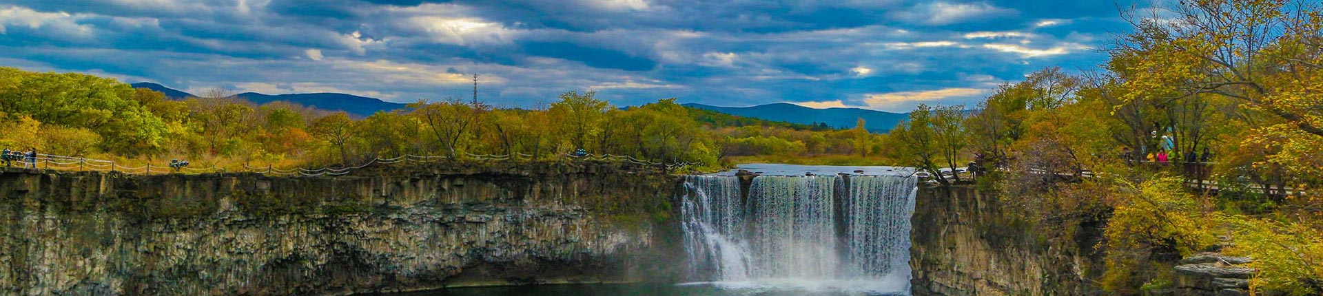
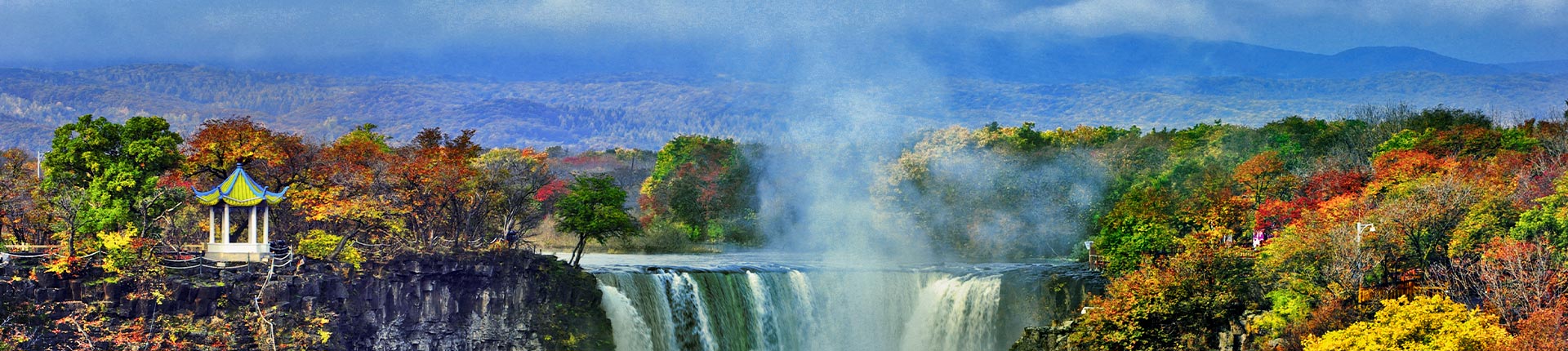
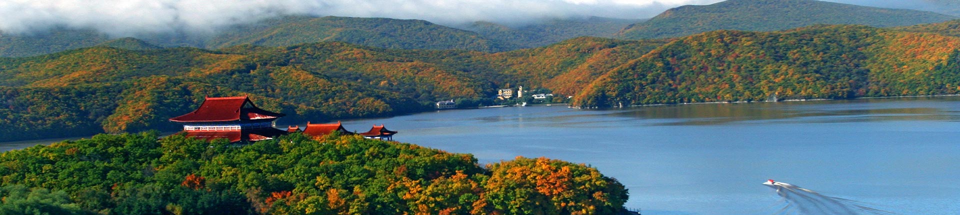
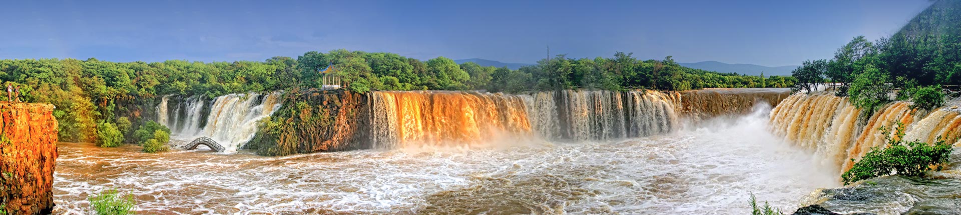
2. Jingpo Lake is the largest volcanic barrier lake in China, featuring a winding shoreline, scattered islands and bays, steep peaks, and unique formations. The Diaoshuilou Waterfall at the lake's outlet is majestic and ranks among China's six most famous waterfalls. The granite along the lake's shore forms distinctive geological landscapes with its peculiar shapes and rugged terrain, harmonizing dynamically with the lake and forests to create a beautiful natural scenery.
3. The park contains rich cultural relics, such as the Neolithic Yinggeling cultural site and the Tang Dynasty Bohai Kingdom ruins, which blend harmoniously with the natural landscapes. This integration endows Jingpohu UNESCO Global Geopark Park with substantial educational and research value, aesthetic appeal, ecological significance, as well as historical and cultural importance.
4. Jingpo Lake and its surrounding environment remain well-preserved in their natural state, complemented by diverse supporting landscapes and overall scenic coordination. With excellent accessibility and sightseeing conditions, it has become a renowned tourist destination both domestically and internationally.
III. Natural Landscapes
1. Unique and rare volcanic geological landscapes. Within a 40-kilometer radius in the northwestern part of Jingpo Lake Scenic Area, there are 12 volcanic craters of varying sizes, with diameters ranging from 70 to 550 meters and depths from 30 to 132 meters. This volcanic group has been erupting continuously for a million years, with the last eruption occurring approximately 4,800 years ago. The lava rivers and lava plateaus outside the Jingpohu Volcanic cones are primarily composed of black basalt. On these plateaus, large-scale lava tunnels—rare in China—are distributed, featuring similar internal structures and peculiar shapes. The longest lava cave extends up to 10,000 meters, making it the largest and most intact lava tunnel discovered in China to date. Even in midsummer, icy scenery can still be seen inside the caves, with chilling air, while some caves are shrouded in mist, appearing deep and mysterious. These features hold significant scientific research value, though no systematic investigation has yet been conducted by experts. The lava plateaus also showcase various unusual volcanic lava formations, such as lava bridges. Due to the ancient and varied eruption periods, combined with Jingpo Lake's favorable geographical environment, the craters are now covered with dense primitive mixed coniferous-broadleaf forests and pure Korean pine forests, earning them the nickname "underground forests." The extraordinary scenery and majestic grandeur of these landscapes are unparalleled in China.
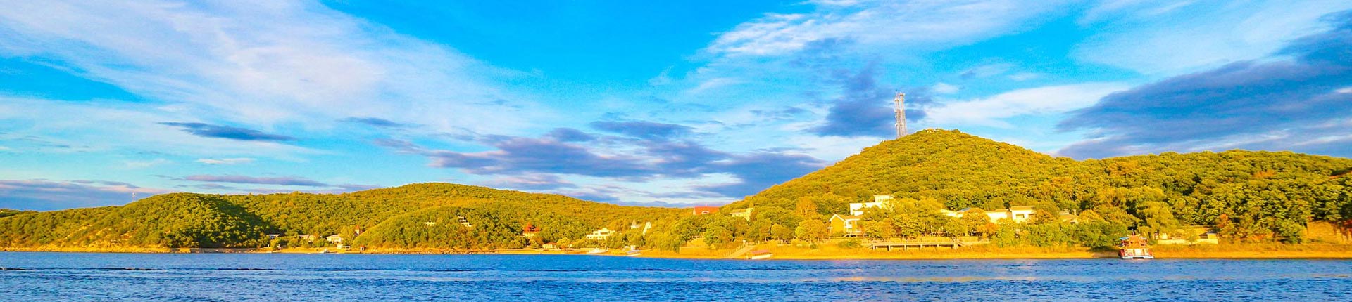
2. Abundant and Diverse Lake Resources. Jingpo Lake is nestled among mountains, with overlapping peaks and winding waters that sometimes lie as smooth as a mirror and at other times ripple gently, presenting an exceptionally beautiful scene. The lake is further adorned with famous scenic spots such as White Rock Cliff, City Wall Cliff, Crow Cliff, Pearl Gate, Mao Gong Mountain, Big Solitary Hill, Small Solitary Hill, and Taoist Mountain, creating unique natural wonders.
3. The Majestic and Spectacular Diaoshuilou Waterfall. Located at the northern end of the hundred-mile-long Jingpo Lake, Diaoshuilou Waterfall features a circular plunge pool formed by black basalt, with a drop of 20 meters. During the high-water season, it overflows on three sides, stretching over a hundred meters in width and discharging 4,000 cubic meters of water per second. The roaring waters tumble down in a magnificent display, creating a thunderous sound and a breathtaking sight.
4. Rich flora and fauna resources. The unique geological formations have created diverse vegetation landscapes and a wide variety of plant species. The park's vegetation is well-preserved, with a coverage rate exceeding 90%. This area belongs to the temperate broadleaf mixed forest zone, featuring typical vegetation such as Korean pine forests, mixed Korean pine-broadleaf forests, and deciduous broadleaf forests. On sunny slopes or drier habitats, Mongolian oak is distributed, while in shady and moist environments, broadleaf species such as maple, linden, Manchurian ash, elm, and birch thrive, along with plants like magnolia vine, mountain grape, hardy kiwi, and fir, as well as juniper.
IV. Cultural Landscapes
The park boasts abundant cultural landscape resources, including scenic architecture, folk ancestral temples, religious buildings, commemorative structures, historical ruins, and cliff inscriptions.
1. Primitive Society Village Ruins. According to archaeological surveys, nearly 10 primitive village ruins have been discovered within the park, including Yinggeling, Songyiqiao Village, Houyu Village, Zhenzhumen, and Bohai Town. The Yinggeling site is the most typical. Located near Jingpo Village in Jingpo Township, this site includes four residential remains and one ash pit, yielding a large number of agricultural tools, household utensils, fishing implements, and bone artifacts.
2. Ruins of the Bohai Kingdom from the Tang Dynasty. The Bohai Kingdom was a local feudal regime established primarily by the Mohe people during the prosperous Tang Dynasty and was subordinate to the Tang Empire. The park contains numerous and renowned ruins from the Bohai Kingdom period. Archaeological discoveries include ancient city ruins such as Shangjing Longquanfu, Chengqianglazi, Dashitouhezi, Xihuzuizi, and Nanhutou. Architectural ruins include Baihuadianzi (west of the reservoir in Xingshan Township). Burial sites include Dazhujiatun and Fengshuiwaizi. Additionally, an ancient kiln site was discovered near the brick factory of the Xingshan Commune.
3. Ancient City Site from the Liao and Jin Dynasties - Chengzi Houshan City. Located on the eastern side of the Jingpo Lake waterfall, the city walls are well-preserved and still stand about 2 meters higher than the ground inside the city and up to 5 meters higher than the surrounding area outside. A bronze seal inscribed with the era name "Tiantai" was unearthed here. "Tiantai" was the era name of the Eastern Xia Kingdom, making the Eastern Xia relics of significant historical and scientific research value.
4. Ming and Qing Dynasty Sites - Xinglong Temple and Sanqing Temple. Xinglong Temple is located 0.5 km southwest of Bohai Town. Originally built as the Stone Buddha Temple during the Jin Dynasty, it was later damaged and reconstructed during the Qing Dynasty's Xianfeng era (as recorded on a stele). Commonly known as the South Great Temple, it is the best-preserved complex of early Qing Dynasty temples in Heilongjiang Province, with the large stone Buddha and stone lantern tower inside being particularly precious. Sanqing Temple, built during the Qing Dynasty's Xianfeng era, is located on Taoist Mountain, and now only ruins remain.
5. Revolutionary Sites: Ning'an County served as a base for the anti-Japanese struggle, with the Second, Fourth, and Fifth Armies of the Northeast Anti-Japanese United Army operating within its territory, leaving behind numerous war relics, secret camps, and sites of sacrifice. Examples include Sandaogou in Jingpo Township's Qingfeng Village, Xiaowangou in Jingpo Township, Xingshan Township, Bohai Town, the Anti-Japanese United Army's secret camps, the Anti-Japanese War Monument, and the Green Great Wall.