1. Core Values
Jingpohu UNESCO Global Geopark in China (hereinafter referred to as the Park) boasts geological relics of international and national significance, including Jingpo Lake, Diaoshuilou Waterfall, and lava flow geological remains.
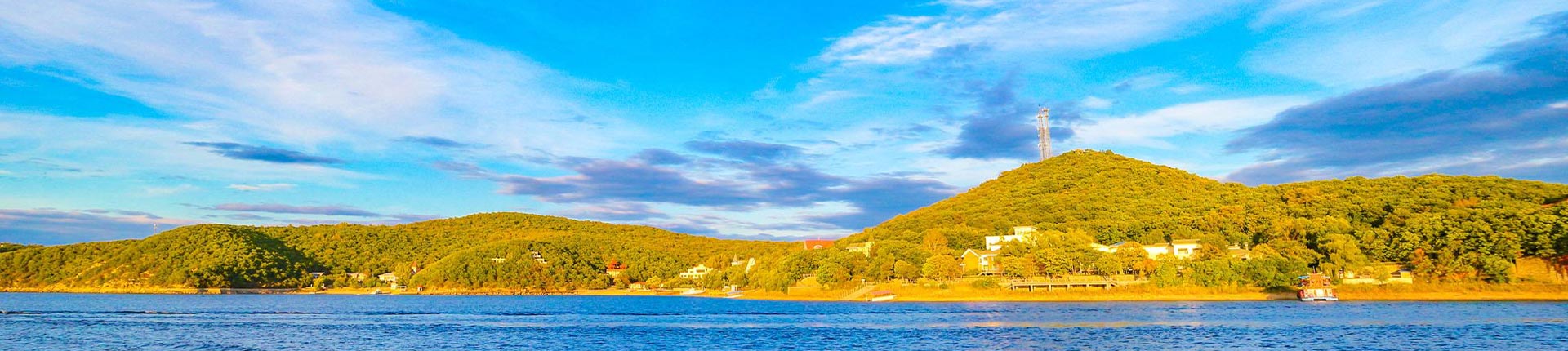
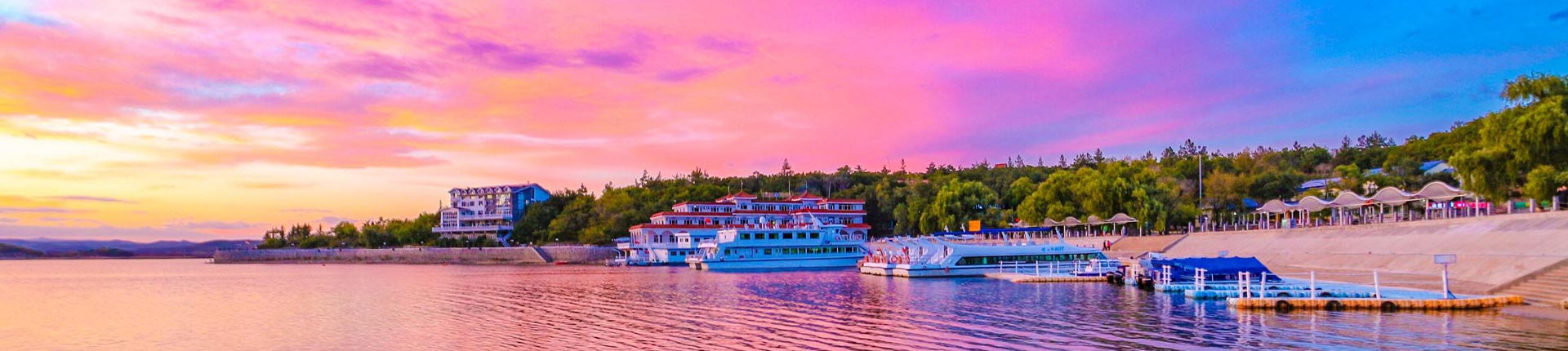
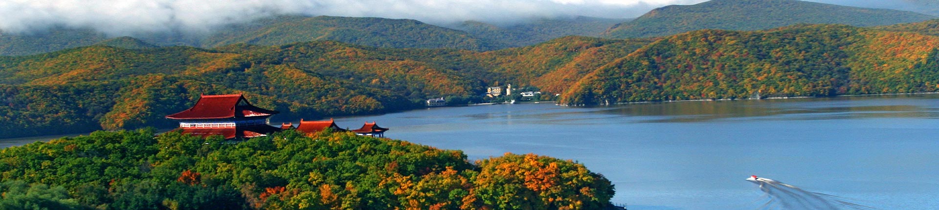
1. Jingpo Lake Landforms Jingpo Lake is located in the central-southern part of the park, with geographical coordinates between 128°30′–129°10′ east longitude and 43°36′–44°20′ north latitude. The lake's surface averages an elevation of 350 meters. It stretches from Nanhutou in the south to Beihutou in the north, spanning a total length of 45 kilometers. During the high-water season, it flows into the Mudan River via the Diaoshuilou Waterfall. The lake runs from northeast to southwest, winding in an "S" shape. Its widest section, near the Camel Peak and Laogua Lazi areas in the southern part, measures approximately 6,000 meters, while its narrowest point, at Yuwazi in the northern part, is about 400 meters wide, with an average width of 1,500–2,000 meters. Covering a total area of 79.30 km², it is the world's largest volcanic lava-dammed lake. |
| |
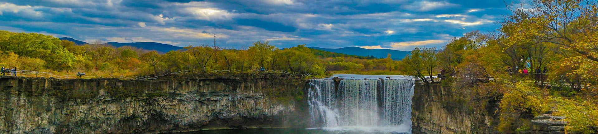
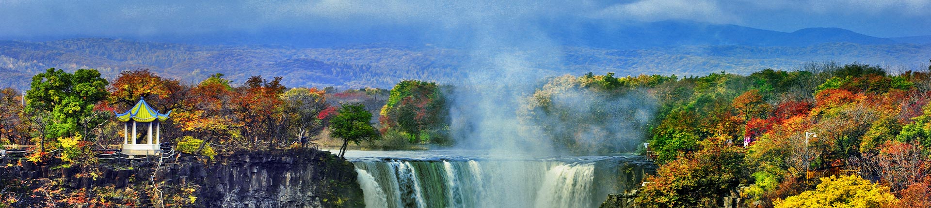
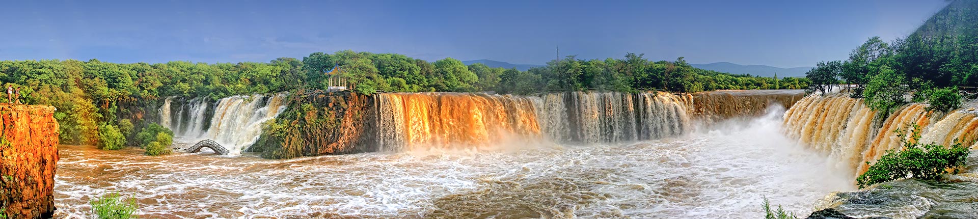
2. Diaoshuilou Waterfall Diaoshuilou Waterfall is the world's largest basalt waterfall and one of the most renowned natural landscapes of Jingpo Lake. Located at the northernmost tip of Jingpo Lake, it serves as the outlet where the lake discharges into the Mudan River. The waterfall stands at an elevation of 349 meters at its highest point, with a drop of 12-14 meters and a curtain width of over 40 meters. During the flood season, the maximum curtain width can exceed 400 meters, while the Black Dragon Pool beneath the waterfall has a diameter of over 100 meters. The water flow peaks in July and August during the rainy season. As the lake water plunges from the cliff into the deep pool, it creates roaring white waves and thick mist, accompanied by a deafening sound. Within the swirling mist, vibrant rainbows frequently appear, presenting a spectacular and mesmerizing sight. |
| |
3. Lava Flow Geological Relics %% The lava erupted from the Underground Forest Volcano, Wudaogou Volcano, and Mihunzhen Volcano spans a total elevation drop of 761 meters from the crater to the end of the lava flow, extending 65 kilometers in length. Viewed as a whole, the lava flow resembles a black "giant dragon" stretching across the rugged mountains. It has formed various micro-landforms, including slightly undulating ridges, mounds, drumlins, lava dams, stone ponds, lava gas caves, lava collapses, tension cracks, fumarolic cones, wavy lava, ropy lava, reptilian lava, and bun-shaped lava. %% 4. Lava Tube Geological Relics %% Along the 26-kilometer lava flow from the "Underground Forest" crater to Xiaobeihu, a total of 10 collapsed lava tube entrances have been discovered so far. The longest continuous stretch extends nearly 2 kilometers, while others typically range from 15 to 50 meters in length. The overall distribution of the lava tubes aligns with the direction of lava flow, trending northwest to southeast. However, the local orientation of individual tubes intersects with the lava flow direction at certain angles. The structures of the tube entrances, ceilings, walls, and floors are similar yet exhibit unique forms. The cave ceilings feature multicolored lava stalactites, while the walls display horizontally developed lava beds and basins. The cave floors are adorned with lava flowers and ropy lava formations. The lava erupted from the Underground Forest Volcano, Wudaogou Volcano, and Mihunzhen Volcano spans a total elevation drop of 761 meters from the craters to the end of the lava flows, covering a distance of 65 kilometers. Viewed as a whole, the lava flow resembles a massive black "dragon" crouching among the towering mountains. It has formed slightly undulating ridges, mounds, drumlins, lava dams, stone ponds, lava gas holes, lava collapses, tension cracks, spatter cones, ropy lava, pahoehoe lava, caterpillar-like lava, and bun-shaped lava, creating a diverse micro-relief of lava flow features. |
| |
4. Lava Tube Geological Relics In the approximately 26 km long lava flow from the "Underground Forest" crater to Xiaobei Lake, a total of 10 collapsed entrances of lava tubes have been discovered so far. The longest continuous stretch extends nearly 2 km, while the others generally range from 15 to 50 m in length. The overall distribution of the lava tubes aligns with the direction of the lava flow, trending northwest-southeast. However, the local orientation of individual tunnels intersects with the direction of the lava flow at certain angles. The structures of the entrances, ceilings, walls, and floors of these tunnels are similar, yet each possesses unique features. The cave ceilings are adorned with various types of lava stalactites, the walls feature horizontally developed lava shelves and basins, and the floors display lava flowers and rope-like formations. |
| |
5. Granite Geological Relics %% The park features granite outcrops covering an area of 1143 km², composed of medium- to coarse-grained granite containing numerous enclaves and schlieren of fine-grained diorite of varying sizes, with well-developed intersecting fissures traversed by diverse dikes of varying widths. Under the intense hydrodynamic erosion downstream of waterfalls and prolonged freeze-thaw spheroidal weathering, remarkably lifelike mimicry stones resembling crocodiles and giant turtles have formed. Erosion creates potholes and grooves of various sizes and shapes—when enclaves or schlieren in the rock are eroded away, they leave behind hollows or nests, while those remaining protrude as knobs. Among these, the formation of potholes is particularly fascinating: jointing and weathering cause granite to break apart, forming cavities. The turbulent river water then rotates rock fragments and finer sediments within these cavities, grinding them over time through lateral and downward abrasion. This process carves out potholes with narrow openings and wider interiors, resembling mortar bowls, while the central rock fragments are polished into spherical pearl stones. Within the park, the exposed granite covers an area of 1143 km², consisting of medium to coarse-grained granite with numerous enclaves and schlieren of fine-grained diorite of varying sizes. The rock is intensely fractured with a network of crisscrossing fissures, intersected by dikes of varying widths. Under the powerful hydrodynamic erosion downstream of the waterfall and prolonged freeze-thaw weathering during geological periods, remarkably lifelike mimicry stones resembling crocodiles and giant turtles have formed. The erosion has created potholes and grooves of diverse sizes and shapes. When enclaves or schlieren in the rock are eroded away, they leave behind cavities or nests, while those not fully detached form protruding knobs. The formation of potholes is particularly intriguing—granite joints and weathering cause the rock to break apart, forming hollows. The turbulent river water then drives rocks and finer sediments within these hollows into continuous rotation. Over time, this side and bottom abrasion grinds the granite hollows into potholes with narrow openings and wider interiors, resembling mortar bowls. Meanwhile, the central rock fragments are polished into spherical pearl stones. |
|
II. Geological Heritage Inventory
There are 70 geological heritage sites within the Jingpohu UNESCO Global Geopark in China. The list of geological heritage sites is shown in the table below.
Serial Number | Geological heritage | Serial Number | Geological heritage | |
1 | Crater Forest Composite Volcanic Cone | Crater I | 36 | Interconnected Caves |
2 | Crater II | 37 | Cave within a Cave | |
3 | Crater III | 38 | Underground Lava Waterfall | |
4 | Crater IV | 39 | Diaoshuilou Waterfall | |
5 | Daganpao Composite Volcanic Cone | Crater V | 40 | Lotus Bay |
6 | Crater V-1 | 41 | Wenbo | |
7 | Toad Pond Composite Volcanic Cone | Crater VII | 42 | Gurgling Jade Pool |
8 | Wudaogou Composite Volcanic Cone | Crater VI | 43 | Jingpo Lake |
9 | Crater VIII | 44 | Xiaobei Lake | |
10 | Crater IV | 45 | Drill Core Lake | |
11 | The maze of composite volcanic cones | Crater X | 46 | Mandarin Duck Pool |
12 | Crater XI | 47 | Xuanwu Lake | |
13 | Apricot Mountain Compound Volcanic Cone | Crater I | 48 | Xiangquan |
14 | Crater II | 49 | Longquan | |
15 | Crater III | 50 | Ziling Lake | |
16 | Crater IV | 51 | Mao Gong Mountain | |
17 | Lava River | 52 | Dalong Bozi Mountain | |
18 | Lava Platform | 53 | Xiaolong Bozi Mountain | |
19 | Jet cone | 54 | Daoshi Mountain | |
20 | Jet Disc | 55 | Pearl Gate | |
21 | Underground Lava Waterfall | 56 | Little Gu Mountain | |
22 | Charcoalized Wood | 57 | Big Gu Mountain | |
23 | Lava Bridge | 58 | Yama's Nose | |
24 | Tianshengqiao | 59 | Stone Mushroom | |
25 | Lava Tunnel | 60 | White Rock Cliff | |
26 | Longyan Cave | 61 | Crow Cliff | |
27 | Underground Labyrinth | 62 | Buddha Cliff | |
28 | Lion Rock Cave | 63 | Deer Park Island | |
29 | Ancient Ice Cave | 64 | A Pinch of Fur | |
30 | Divine Water Cave | 65 | Heron Island | |
31 | Sister Cave | 66 | Granite Monadnock | |
32 | Weihu Hall Cave | 67 | City Wall Cliff | |
33 | Anti-Japanese Allied Forces Secret Camp Cave | 68 | Eastern Lapis Lazuli World | |
34 | Looking at the Sky from the Bottom of a Well | 69 | Jingpo Canyon | |
35 | Divine Goat Cave | 70 | Granite Stone Forest | |
III. Main Protection Measures
The geological relics of Jingpo Lake are protected under a tiered system, dividing the park into: Special Protection Zone, Level I Protection Zone, Level II Protection Zone, and Level III Protection Zone.
Special Protected Area Requirements: Complete isolation from visitors is mandatory, and no human habitation is permitted; all production activities are prohibited, and no construction unrelated to conservation facilities is allowed—only maintenance is permitted, with no creation allowed; visitor numbers must be strictly controlled, with dedicated personnel responsible for environmental monitoring.
Protection Requirements for the Primary Protection Zone: Any quarrying activities are strictly prohibited within the primary protection zone. Tourism is permitted only along designated routes and at approved sites authorized by the provincial land and resources administrative department, with comprehensive protection and management measures in place. Areas outside the designated routes and approved sites are off-limits to tourism and other activities, and visitor access must be strictly controlled. All production activities are banned in the primary protection zone. Construction is prohibited except for essential protection facilities. No residents are allowed to reside in the zone, and existing residents must relocate within the specified timeframe. Farmland must be restored to forests or grasslands. Visits, research, scientific studies, and international exchanges may only be conducted in specifically designated areas with approval from the provincial land and resources administrative department.
Level II Protected Area Conservation Requirements: Mining of volcanic scoria is prohibited; the volcanic cones and craters must be protected from damage; safeguard the volcanic barrier lake—Yuanyang Pool—and prevent water pollution; tourism sites within the area should highlight natural landscapes, and no artificial structures that disrupt these landscapes may be constructed; organized scientific research, teaching, academic exchanges, resource development, and appropriate tourism activities may be conducted with approval from the provincial land and resources administrative department.
Level III Protected Area Conservation Requirements: Develop tourism based on volcanic geological heritage landscapes, ecological forestry, and ecological agriculture; transition the local workforce from current agricultural operations to tourism and ecological forestry gradually; this area is a key and challenging zone for restoring ecosystem balance, requiring that all development prioritize ecological impact, with the environment holding veto power over any project; restrict illegal land occupation for operations and implement unified planning for conservation management.